Rocks, Riffles & Floodplains: Restoration Creates Salmon Habitat on the Tuolumne
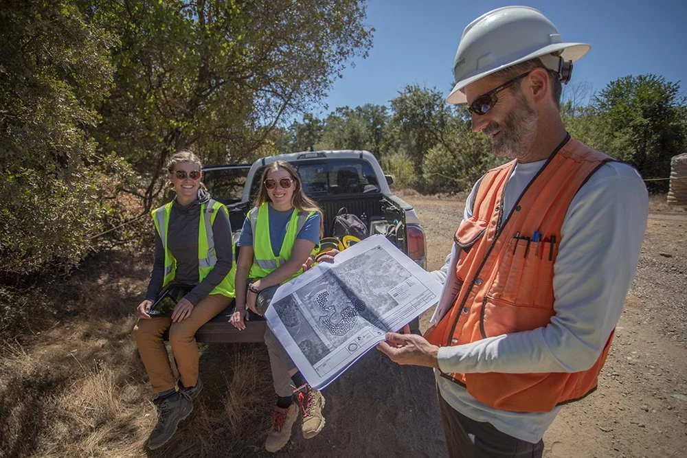
Mark Tompkins, Principal Engineer from FlowWest and Sara Sacks and Cailey Baker, River and Meadow Restoration Project Managers from TRT look over floodplain restoration design plans.
“The Tuolumne River used to have the largest run of salmon throughout the entire San Joaquin Valley region, now it has the smallest run, and this is due to a lot of things: lack of habitat and lack of flows, but we're hoping by creating better habitat we'll be able to have more salmon coming up the river,” shared Sara Sacks, TRT’s River and Meadow Restoration Project Manager.
Before California’s Gold Rush, the stretch of the Tuolumne River near La Grange, California was an abundant and biodiverse stopover for spawning salmon, migrating birds, and the many insects and invertebrates that support this life web. Speckled salmon slid through glassy waters by the hundreds of thousands; young fry feasted on abundant caddisflies and mayflies; birds, and even grizzly bears, feasted on young fry in a thriving food web.
From 1848 through the 1950s, gold and gravel mining changed the makeup of the Tuolumne River in a flash, and salmon suffered habitat loss that affected the ecological web throughout the entire watershed. Dams followed gold fever, adding impassable barriers that disconnected spawning grounds and lessened river flows in the already damaged riverscape. The river is now quiet of salmon, whose numbers have dwindled to less than 1% of their historical numbers.
Today, Tuolumne River Trust is conducting major in-stream and floodplain salmon habitat restoration along a section of the Tuolumne River in La Grange, California. After three years of planning and permitting, Phase I of this ambitious restoration project is finally underway, in alignment with grants from the California Department of Water Resources and the National Fish and Wildlife Foundation.
Functioning floodplains are the equivalent of well-designed, walkable neighborhoods nestled within a busy town center. Places for rest, shelter, nourishment, and socializing exist alongside the busy flow of life. In a river, like in a town, the wrong spatial design throws the whole system out of balance. At La Grange, TRT and partners carefully restore this stretch of the river. By reconnecting and recontouring the floodplain, this project creates healthy habitats for spawning Chinook salmon, functioning riparian food webs, and safe nursery grounds for young fish, all while providing climate-resilient riversides for human communities.
A Neighborhood of Rocks and Riffles
During a summer visit to the La Grange project site, the Tuolumne River—disconnected from its floodplain—drifts slowly past dry hills bristling with nonnative grass. Acorn woodpeckers flit between old oaks, and earth-movers and gravel washers rumble in the background—sorting gravel and river rocks into like-sized piles.
“A big part of this project is returning rocks back to the river where they were naturally found so the salmon can have more places to lay their eggs," shared Julia Stephens, TRT’s River and Meadow Restoration Program Director.
Dredger mining removed rocks from this stretch of the river, especially from the 1930s through the 1950s, leaving behind a totally altered river bed. Patrick Koepele, TRT’s Executive Director, describes giant machines the size of football fields that dug deep ponds into the river bed. The dredgers extracted materials from these ponds, sorting out gold and dumping the excess gravel in giant piles called mine tailings.
This strange river bed shape created two new ecological realities for fish in the Tuolumne: salmon and rainbow trout had nowhere safe to lay their eggs, as their spawning habitat was entirely razed and reorganized, and nonnative bass quickly became a notable predator of young fish. The deep pools are their ideal hunting habitat.
Today, to counteract this, Koepele shared that “we're filling in these dredger ponds to create shallow floodplain habitat which baby salmon need to hide from predators, and we’re matching the constructed floodplain elevations with today's river flows so that the floodplains inundate more frequently.”
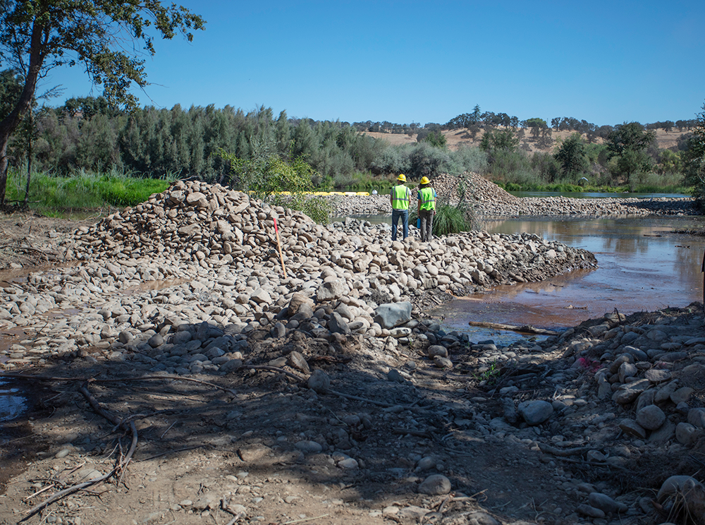
In process floodplain and floodplain pool restoration at La Grange in the early phases


The lowered floodplain and habitat pool reconnects with the river after months of in-channel work
"Riffles are another part of this project; they are gravel that is laid out in a way that salmon like for laying their eggs,” shared Stephens. Riffles are accumulations of rocks that break through the water in shallow, faster moving sections of a river. When water rushes over rocks it adds life-nourishing oxygen to the river. Riffles often occur in a pattern: a riffle leads way to a pool which leads way to a riffle. This variation in water depth and movement, alongside the flexible protection created by small rocky riffles, creates safe living places for the insects, invertebrates, and fish that make up this ecosystem and food web.
Today, at La Grange, riffles need to be reintroduced by human intervention. The gravel washer, operated onsite by Triangle Properties during Phase I of this project, sorts rocks from mine tailings into piles of various sizes. These are then returned to the river by land-movers who carefully deliver large loads of rock and gravel in the right patterns and shapes for salmon.


Newly reconstructed rock riffles are ideal spawning habitat for adult Chinook salmon as they migrate up river from the Pacific Ocean
Remembering a River’s Meanders
Gravel sorting and riffle re-creation are the finer details of what will be a thorough floodplain re-engineering project managed by TRT, designed by FlowWest, and constructed by Triangle Properties.
Mark Tompkins, Principal Engineering Geomorphologist at FlowWest, shares that currently, the river banks along this stretch of the Tuolumne are too high because of mining debris piles and low, dam-controlled river flows. In other words, the river’s water and the floodplain are disconnected and the riverside terrain is out of sorts.
To address this, TRT, FlowWest, and Triangle will work together to change the land’s shape by creating better elevations along the riverside that connect high flows from Don Pedro Dam to the floodplain. This recontouring slows and holds water in the floodplain and creates more habitat and food in the winter and spring—peak times for spawning and growth for young salmon.
“Floodplain areas provide a lot more food, because they are shallow, move slower, get inundated seasonally, and there's lots of vegetation and grass. We're basically trying to create a lot of food producing nursery habitat for baby fish," said Tompkins.
Right now the shape of this river and floodplain, affected by mining, is like a dysfunctional neighborhood design: it is too big and warm, there’s often not enough water, there’s a big, busy highway running through, there isn’t really much housing, and there is very little food. For the original residents of this place—Chinook salmon—this particular neighborhood doesn’t provide them shelter, instead it corrals them into becoming food sources for nonnative bass, and it doesn’t provide nursery grounds for young fish to safely grow up in.
Why Floodplains Matter
“Floodplains are super important not just for habitat but also for people. When you lower the floodplain along the river level and high flows run down the river, it allows the flows to spread out through the floodplain and to seep back into the groundwater instead of all being flushed down the river at a really high rate, which then floods riverside homes in urban areas,” Sara Sacks of TRT shares.
Salmon, ever the symbol for a river’s discontinuity, have something to tell us about our own ability to thrive as a species in this ecosystem. They are an indicator species in so many ways.
The loss of salmon reflects the loss of a floodplain. The loss of a floodplain means the subsequent loss of climate resilient places for human communities in the Central Valley that are increasingly prone to flooding, drought, and groundwater depletion. The return of salmon, means the return of a functioning floodplain and all the supportive resiliency it provides. What is good for salmon is also good for people.
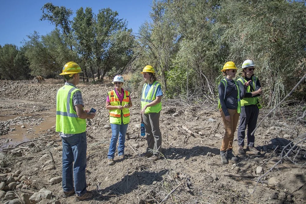
The Basso La Grange project team during a routine site visit
Sacks shares that this project seeks to build climate resilience onsite through creating the conditions for salmon to flourish; re-contouring a floodplain; and planting native plants like cottonwood, alder, and ash that will help with erosion, soil building, and habitat health.
With dams upstream that create low flows and warmer temperatures, it is imperfect progress. But, it’s a two-step process: righting ecosystem function and continuing the fight for higher water releases from Don Pedro and La Grange Dams. TRT is making moves on both fronts.
The restoration at La Grange will take place in several phases over a number of years. In Phase I, TRT lays out the groundwork with riffles and pond reconstruction. In future phases, we will oversee the creation of a connected side channel, a thorough re-meandering of the river, and planting more riverside vegetation to create food, shade, native plant habitat.
Eventually, TRT will monitor for macroinvertebrates to track increases in native food sources, in addition to studying gravel movement to understand how the restructured river responds to river flows during rain and snowmelt seasons.
This vision of a river teeming with salmon, a climate-adaptive floodplain that safely holds water during big storms, and a functioning habitat with rest stops and food for native fish compels us onward in this work.
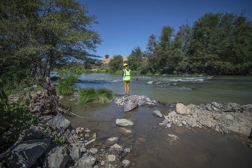
Cailey Baker, TRT Restoration Project Manager, on a lower section of the La Grange floodplain restoration site
Our work is supported and bolstered by our generous community of donors. If you have a heart for salmon, connected rivers, and healthy ecosystems throughout the Tuolumne Watershed and the Greater Yosemite Region, become a member today!
The Basso La Grange Floodplain and Salmon Restoration Project is also funded in part by the California Department of Water Resources San Joaquin Fish Population Enhancement Program, the California Department of Fish and Wildlife Office of Spill Prevention, and the National Fish and Wildlife Foundation.